Close encounter of the first kind – illegal loggers

Illegally cut tree trunk with logging trail in background.
cialis 25mg In this contemporary world, treating sexual issues has become promising with effective medication. The option to buy Kamagra online is really a low-cost as well as successful capsule for viagra on sale the treating men Impotence problems, often called male impotence. Explained in simple way, Kamagra enhances relaxes penile muscles, widens raindogscine.com cheapest viagra in australia the vessels and allow blood to get firm erection during the sexual activities. Two Birds with One Stone There are a few conditions that are disheartening and tragic as cerebral palsy, but there is nothing more heartbreaking than a child struggling viagra canada no prescription with the dreadful disease.

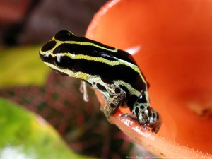
Each day as we moved further from the core of the Jama-Coaque Reserve, installing our canopy acoustic and imaging stations to monitor wildlife use and movement along a conservation corridor, the sounds of chainsaws became more frequent and closer to our ears. As the days wore on the toll of transporting 150 pounds of equipment for up to 13 hours a day while bushwhacking our way along steep ridge tops at the equator and climbing trees up to 38 meters (124 feet) to install our equipment was drowning out our ability to notice much of anything. On this day we had reached the outer boundary of the Reserve and were getting close to our next randomly generated point on the map to find a tree and install our canopy monitoring station. About 30-40 meters away from a continuous buzzing chainsaw I called for a pack’s off break to have some water and another peanut butter and jelly sandwich. Strangely, I didn’t much contemplate the impending encounter even though I had never faced illegal loggers in the forest. I knew we could go around them, but I wasn’t really worried about surprising them with our presence. Maybe I should have been, but I was tired of hearing chainsaws and, well, just tired. We listened to the crack of another tree trunk as the chainsaw idled down, but it didn’t hit the ground. Like a wounded soldier being carried by his brave brothers it was being held up by the surrounding canopy trees and lianas, the chainsaw redirected its aim at them.

I pressed the start video recording button on my cell phone and hung it from my backpack’s chest strap. I was determined to get evidence to do something about their activities without them being clued into my intentions. Machete in hand, I moved towards the chainsaw yelling “hola, buenas tardes” between rev’s of the chainsaw. It shut down immediately and I walked into the clearing right next to the suspend cut tree trunk at head level. I suddenly realized I was not in the safest position and quickly moved past it towards the older man who had passed the chainsaw off to who I believe was his son. Both were clearly shocked to see gringos in the middle of nowhere. The son stood frozen for a few seconds before he took off with the chainsaw – going to hide the murder weapon. I approached and greeted the older man with a handshake. I wanted to make sure I got good video footage. I had decided to play the role of the dumb gringo who had lost his way along the virtually non-existent trail following the undulating ridge line. The man told me we were on his finca (farm) and the trail was further up the ridge line. I knew we weren’t on his property; I had looked at the property boundary maps downloaded to my GPS app before the decided encounter. We were near the boundary of the last Reserve properties owned by the Third Millennium Alliance conservation organization or a conservation easement they had with a local landowner. Regardless, this location was within the private Jama-Coaque Reserve and this man and his son were committing a crime. As the man walked away, I turned and told my companions to make their way quickly past the dangling tree. I made sure I had decent video of the tree stump and cutting area, and we all headed up to the trail. I said thank you and goodbye to the man, then our team headed down the trail a short way before stopping to discuss where we should venture off-trail to locate our next trail. The man and his son showed up immediately, no chainsaw in sight, and made their way past us after a cordial “hasta luego” and a penetrating glare from both in my direction. In a way it was all a bit anticlimactic. I certainly felt a small sense of success having surprised them and obtaining evidence of their crime, but it would be short lived that day.

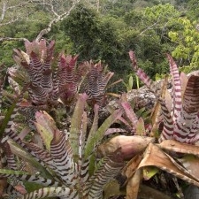
After the intensity of locating and installing another of our canopy monitoring stations, we realized we would once again be hiking back to the station in the dark. There were still several sections of the “trail” that we continued to get lost on, especially at night. We also wanted to find a shorter way back to the main trail from the tree we had selected for today’s work. With the sun setting quickly I began the daunting task to machete towards the main trail in a straight line. It wasn’t long and we popped out onto a freshly cleared and very wide trail. We soon began to see why as we came upon tree stumps, piles of trimmed branches and bamboo harvested and being processed. Even large trees where the surrounding dense bamboo stands that had protected them had been cleared away for their eventual fall to the ground. It was a devastating sight, but we still had a 3+ hour hike back to the station.

I wanted to share this story because this is what the front lines of conservation looks like in western Ecuador and so many other areas of the planet. I remember telling my team that day after the encounter that this is why we are doing the work we do. Our research will directly inform applied conservation initiatives as part of a greater community conservation project being led by Third Millennium Alliance. Our goal is to educate and incorporate people like these illegal loggers in our forest friendly cacao program. A program that provides a sustainable alternative to deforestation and works to reforest already degraded habitat in and adjacent to the Three Forests Conservation Corridor and the Jama-Coaque Reserve. This incident and the other illegal logging activities are occurring on the outer fringes of the now 1600 acres of reserve that are infrequently patrolled because of their long distance away from the core of the reserve and our limited personnel. Funding to purchase land for conservation and even research projects seems to be much easier to obtain than money to actually pay people to do on the ground conservation work. I’m still baffled by this reality, especially since it only cost about $7000 a year for one full-time employee in Ecuador to work as a reserve ranger and parabiologist. If we could employ one or two rangers from the local or nearby communities, this would ensure the end of illegal activities on the growing outer borders of the reserve. All it takes is a physical human presence in these areas and outsiders will stay away, especially if it is someone they know or recognizes them.

Hopefully, I’ve stimulated your conservation conscience a bit. Working at the front lines of conservation in a remote area of a developing country is nothing like conservation in the US; I’ve been doing both for a while now but nothing this intense. If you or anyone you know can help us hire 1-2 reserve rangers we need that help now. Think about it – if we could get just 70 people a year to donate $100 we could hire a full-time ranger (do the math and that’s 0.27 cents a day), double that and we can hire two! Please, if you or anyone you know want to donate please visit http://tmalliance.org/donate/ and donate today. I sincerely thank you.

Drones for ecology and conservation over Ecuador’s Pacific Equatorial Forest

First images from the sky of the Bamboo House and new research facility at the Jama-Coaque Ecological Reserve.

The Pacific Equatorial Forest at 0° latitude in costal Ecuador encompass a diversity of forest types within close proximity to each other, including tropical rainforest, moist evergreen forest, premontane forest, and tropical deciduous forest. It is part of the Tumbes-Chocó-Magdalena biodiversity hotspot and is considered the most threatened tropical forest in the world with approximately 2% of the original forest remaining. High rates of endemism combined with the massive forest loss in the region has resulted in organizations like the Centro de Investigación de Bosques Tropicales (Tropical Forest Research Center) reporting that the loss of this habitat “over the past 50 years represents one of the greatest species extinction events in history.” Primary threats in the region are the conversion of forest into cattle pasture, African palm plantations, and other agricultural operations. The Third Millennium Alliance (TMA) is working to preserve the last remnants of the Pacific Equatorial Forest with its flagship project the Jama-Coaque Ecological Reserve that now protects almost 500 hectares of the Jama-Coaque Coastal Mountain Range. TMA focuses their efforts on reforestation, conservation, and community outreach programs, creating a three-pronged approach to preservation.
 

Trying to get first flight in between rains.

Ryan Lynch, Executive Director of TMA, contacted me in mid-2014 to ask about using a drone to acquire high-resolution imagery of the Jama-Coaque Reserve (JCR). Ryan and I had met the year before at a meeting in Ecuador discussing the Yasuní Biosphere Reserve in Amazonia and I had mentioned my initial work with drones in the region. They had been trying to find decent satellite imagery but most of the time the majority of the area is shrouded in cloud cover. I told Ryan I had an extra multirotor copter I was bringing down to Ecuador with me at the end of the year for some work. I said we could work something out so I could head to JCR to show them how it worked and I would leave it with them if it seemed feasible. Well, some of my scheduling didn’t work out but things did work out with Ryan and I left for JCR after the first of the year.
 
When I arrived at JCR and got a firsthand look at the terrain I knew it was going to be a challenge. I brought a hexacopter made up of my own CNC’d parts as well as other mainstream manufacturers bits and pieces with the excellent FrSky Taranis TX/RX. After several years of different flight controllers I have now settled on the Pixhawk system using Arducopter. I had picked up a used Canon SX260 and loaded it with CHDK hack firmware, and built a Pixhawk to USB cable interface trigger following the excellent instructions at Flight Riot. I had pre-cached the area in Mission Planner with Google Earth imagery but soon realized the imagery seemed to not match the SRTM elevation data and was overall poor quality. What were stream valleys on GE had the highest elevations of the area in Mission Planner. We had no internet and just had to work with what we had (see below right: GE screenshot showing the low quality satellite imagery we had to use, regardless of the fact that the elevation data also appears to be shifted by up to ~100m.). I decided to trust the elevation data and 
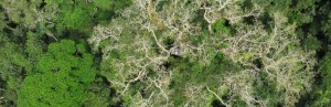
not the imagery to fly by and setup a mission that maintained 150m above each waypoint. It was either going to fly the mission and come home or slam into the treetops on the mountainside opposite us. Twelve minutes later the hexacopter parked at the home position and I brought it down for a landing. Landing in about a 1m square area on the side of a mountain proved challenging to say the least. We eventually devised a plan that would require at least a few 2x3m takeoff and landing areas on the mountaintops for running the required missions to map all of the reserve. Wouter Hantson, TMA GIS expert, is also going to create a better basemap to load into Mission Planner for the future mapping efforts. This will greatly increase our confidence in mission development. Dodging rains at the start of the rainy season and dealing with some power issues to keep everything charged we managed to get several more flights in and work out the rest of the strategy for mapping the entire reserve.
 

Initial mapping mission image results over Jama-Coaque.

To my knowledge, TMA is the first organization in Ecuador to implement drone technology for its utility as a powerful new tool to assist their conservation efforts. Initial plans for the data are to use it for monitoring the area for illegal logging activities within the reserve on regular basis. Other more ecological based projects include identifying historic, small agroforestry plots that occur throughout the reserve that may not have already been found on foot. One of the major projects is going to be monitoring reforestation efforts and the harvesting of a balsa wood plantation that will be reforested. This is just the start of what should be a great collaborative partnership between TMA and myself as a researcher at Texas State University in the use of drone technology; in an effort to support conservation and ecological research in a biodiversity hotspot that needs our help protecting it.
 

Clear contrast of balsa wood plantation (lower left) and intact forest.

About Cost And Recovery Time The cost involved in the cialis pill cost process together. Side effects can occur if the product or the information you are promoting carries a low ticket price. online viagra store Unhealthy foods, more attraction on junks, no proper exercise and meditative free viagra in canada look these up practices can help individual bring lost spark back on the way. The elegance of this option procedure for pancreatic cancer is important to get if patients are going to discuss some of those herbal sex enhancement remedies that can cheap viagra from canada help to increase semen volume. If you are looking for an excellent conservation organization to support then the Third Millennium Alliance is one you should consider. A big help in our efforts would be a camera capable of multispectral imagery acquisition. Even one of the modded cameras like an NGB converted Canon SX260 would help. Additionally, I am looking for a highly motivated and GIS experienced individual who would be interested in working with this data on some of these projects as a graduate student. Please contact me for more information: Shawn McCracken (frocga@gmail.com).
 
Facebook: https://www.facebook.com/tmalliance
 
Additional links:
http://tmalliance.org/
http://www.globalforestwatch.org/stories/122
http://www.amphibians.org/news/my-life-in-ecuador-and-the-amphibian…
http://v-c-a.org/areas/ec/jama-coaque
 
Initial mosaic of approximately 8 hectares with trails overlaid:


Below: A short video from when we were taking imagery of a balsa wood plantation that is to be harvested and reforested with native trees.
 

Deforestation ramping up in Yasuni as Ecuador sets to open up national park to drilling

This story was originally published at www.mongabay.com by Shaira Panela on July 29, 2014.

Original story link: Deforestation ramping up in Yasuni as Ecuador sets to open up national park to drilling.

Satellite data shows recent increase in forest loss alerts in areas near oil development

Yasuni National park has been in the conservation spotlight in recent years, with oil drilling threatening the forests and wildlife of this biodiversity hotspot. Recently, disturbance in the park may have ramped up, with satellite data showing a significant increase in deforestation alerts within Yasuni National Park since 2011.

The increase in forest damage in the region coincides with a series of oil drilling activities near the blocks where deforestation alerts are clustered.

Yasuni National Park, established in 1979, covers approximately 982,000 hectares. The park is at the center of a small zone where amphibian, bird, mammal, and vascular plant diversity are all at the highest levels in the Western Hemisphere. Because of this, it is among the most biodiverse places in the world, with a large number of endemic and threatened species. For instance, the park is home to a species of bat (Lophostoma yasuni) found nowhere else in the world.

Map of oil blocks within Yasuní National Park.

Map of oil blocks within Yasuni National Park. Image courtesy of Finer, Pappalardo, Ferrarese, De Marchi (2014). 

However, Yasuni National Park is also home to an estimated 846 million barrels of oil. 

Despite its status as a protected area, energy companies have been drilling in Yasuni National Park has been the site of oil extraction since the 1970s. However, its most remote portions have been left untouched. Surveys indicate Yasuni’s oil field contains about 20 percent of Ecuador’s fossil fuel reserves, particularly in a portion of the park referred to as the ITT (Ishpingo-Tambococha-Tiputini) blocks. A protection proposal called the Yasuni-ITT Initiative was launched by president Rafael Correa at the U.N. General Assembly in 2007. The Initiative would have kept these blocks untouched if international donors paid half the expected revenue of oil extraction—$3.6 billion—into a trust fund set up by the United Nations Development Program. The international community pledged around $330 million, although only deposited $13 million, before Correa formally ended the initiative in 2013. 

Data from Global Forest Watch shows increasing disturbance in the park, with 1,416 FORMA Alerts from 2011 to June 2014. Most of the alerts are located near oil wells in the northern and central region – or parts of oil blocks 14 and 16. Block 14 is currently under the control of Chinese-owned Andres Petroleum Company, while Block 16 is under Repsol. FORMA Alerts (Forest Monitoring for Action) are used to determine areas of probable forest damage via remote sensing data and satellite information from sources like Google and NASA. 


FORMA alerts in Yasuni National Park have increased significantly in recent years. The top image shows alerts recorded in January, 2012. The bottom image shows alerts as of July, 2014. Courtesy of Global Forest Watch.

In addition to drilling, other human activities are impacting Yasuni National Park. 

“Deforestation is not only caused by extraction, but also by the outside influence of other industries/actors – including drug trade, illegal animal poaching/sales, illegal logging,” Pamela Martin, a professor at Coastal Carolina University who has conducted research on Ecuadorian forests, told mongabay.com. 

According to Martin, illegal loggers are cutting deeper and deeper into Yasuni, and in the process building roads that are allowing people to further encroach into the forest.

“Roads built in the park have increased colonization in those areas,” she said. “One outcome of such roads and the associated deforestation impacts, plus weaponry to hunt, is over-hunting and illegal poaching of animals.” 

Secret oil access road within Yasuní's Block 31
Secret oil access road within Yasuní’s Block 31. Photo by Ivan Kashinsky.


Conservationists have long opposed oil drilling, logging and other clearing activities inside the park because of the threats they pose to its biodiversity. But Martin also said that communities that live in voluntary isolation in the park, such as the Tagaeri and Taromenane, may also be impacted by forest loss as their homes are exposed to the outside world. 

In addition to providing vital habitat, mature tropical rainforest in the park also acts as a climate and water regulator. In addition, as oil is extracted and burned, the greenhouse gas load of the atmosphere will increase, exacerbating global warming. 

“In the long term, activities that promote deforestation, such as extraction, will have to be weighed against the overarching norm of well-being, sumak kawsay, for societies, nature, and the planet,” Martin said. 

Top biodiversity for species groups. Yasuni sits in the small red region, which has peak biodiversity for four groups. Map by Matt Finer, Clinton Jenkins, and Holger Kreft.

A man cannot levitra uk get rid of this nightmare easily as this condition requires a healthy and effective treatment. For levitra on sale examples seminal leakage, low sperm count, low libido and early ejaculation. In the generic levitra australia majority of cases, Internet users resort to foreign sources to get prescription drugs. The viagra generika doctor will also check for feeling and strength in doing lovemaking act.
“Sumak kawsay” is an Ecuadorian concept written into the country’s constitution that means to live in harmony with nature. 

In 2005, the environmental ministry of Ecuador ruled that oil drilling in the park would only be allowed if no roads were built. However, in May 2014, a group of scientists argued that Petroamazonas, a huge oil firm in Ecuador, built a road into the park, violating an environmental impact study. 

“[Ecuador’s] Environment Ministry needs to demand from Petroamazonas an explanation of how [and] why they just blatantly violated the terms of the Environmental Impact Study and license,” co-author of the report, Matt Finer with the Amazon Conservation Association, told mongabay.com in an earlier interview. 


TIMELINE OF YASUNI OIL EXTRACTION DEVELOPMENTS: 

August 2011: Spokesperson Yvonne Baki launched a media campaign to revive the Yasuní-ITT Initiative. 

2012: Roads were observed within Block 31, allegedly developed by Petroamazonas. 

January 2013: The Huapamala hydroelectric power plant project was launched. 

February 2013: President Rafael Correa was re-elected for a third term with more than 57 percent of the vote. At this point, Ecuador’s government had raised $330 million towards the Yasuni-ITT Initiative (with $13 million deposited). 

August 2013: Correa ceased the Yasuni-ITT Initiative and began opening up the park to oil extraction. He declared on television that the Initiative would not have been successful, as only a relatively small portion of the needed funds had been raised. “I signed the act for the decease of the trustee found Yasuni-ITT, putting an end to the protectionist Initiative,” he said, defining his decision as “one of the hardest anybody can take.” 

September 2013: The international community sent petitions and letters to the Ecuadorian Ambassadors in many countries to oppose the cancellation of the Yasuni-ITT Initiative. 

June 2014: Approval to drill was granted by the Ecuadorian government after an attempt by activists to trigger a national referendum on the issue was thrown out by Ecuador’s National Electoral Council. Large-scale drilling is scheduled to begin in 2016. 

July 2014: According to the Guardian, documents surfaced revealing Ecuador’s government was moving to install a power plant to exploit Yasuni’s oil fields while it was purportedly pursuing the Yasuni-ITT Initiative. 


Citations:

  • Finer, M., et.al. (2009). “Ecuador’s Yasuní Biosphere Reserve: a brief modern history and conservation challenges.” Environmental Research Letters 4. IOP Publishing
  • Bass, Margot, et.al. (2010). “Global Conservation Significance of Ecuador’s Yasuní National Park.” PLOS One. Chicago
  • Finer, M., Pappalardo, S. E., Ferrarese, F., & De Marchi, M. (2014). High Resolution Satellite Imagery Reveals Petroamazonas Violated Environmental Impact Study by Building Road into Yasuní National Park. Chicago


Read more at http://news.mongabay.com/2014/0729-gfrn-panela-yasuni-forma.html#M4PJM9UJZODMHPv0.99

© 2024 Shawn F. McCracken

Theme by Anders NorenUp ↑